You will hear a communications manager speaking at a public meeting about a proposed housing development.
First, you have some time to look at questions 11 to 14.
Now listen carefully and answer questions 11 to 14.
It's encouraging to see so many local people here for our presentation about the new housing development proposed for the edge of Nunnston.
I'm Mark Reynolds, the developments communications manager.
I'll begin with a short outline of the scheme, including why this particular piece of land was selected.
It's currently used for agriculture, as is much of the area around Nunnston.
However, the town's new industrial centre has created considerable demand for homes near people's jobs.
At the moment, many employees have very long journeys to and from work, so building here would make life much easier for them.
The international airport is only about 20 minutes away by car.
That's useful, of course, but it wasn't a leading reason for our choice.
Of greater importance was the excellent hospital 15 kilometres away, with a large secondary school even nearer.
The steep slope is one disadvantage of the site, although the plans have been adapted to deal with it, so we don't expect it to cause serious difficulty.
The plans have received a great deal of favourable feedback.
People welcomed the range of housing types and prices, and they liked being within a short drive of the countryside.
Although the development itself won't be in a rural setting, we were especially pleased by support for the layout.
Most respondents felt it suited the natural landscape, and they approved of the efforts to preserve trees and wildlife.
A number of people asked us to improve provision for cyclists, which we'll consider.
Overall, though, residents thought the design and shared facilities would help people of different ages live together as a genuine community.
Before you hear the rest of the presentation, you have some time to look at questions 15 to 20.
Now listen and answer questions 15 to 20.
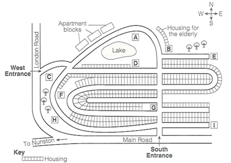
Now I'll show you a map of the proposed development.
Its southern edge follows the main road, which continues towards Nunston, while London Road forms the boundary on the west.
The site will contain roughly 400 houses and three apartment blocks.
We're also providing a school for children aged 11 and under.
Start at the south entrance at the bottom of the map, and follow the road running north through the site.
The school will stand on that road, on the corner of the second, turning on the left.
A large sports centre will offer both indoor and outdoor activities.
It will be on the western side of the development, immediately below the road that branches away from London Road.
Residents will have a clinic for medical problems.
Find the lake near the top of the map.
The clinic will be directly below it on the right-hand side of a row of houses.
There'll be a community centre for every age group as well.
In the northeast, you can see a row of specially designed homes for people over 65.
The community centre will be directly beside those homes.
Shopping has been included too.
The supermarket will lie between the west and south entrances.
The three mature trees close to London Road are being retained, and the supermarket will be immediately south of them.
Younger children will have a playground.
Follow the road north from the south entrance until it bends left at the top.
The playground will occupy the inside of that bend and will look towards the lake.
Right, before I take your questions, is there anything else you'd like me to explain about the plan?
That is the end of part two.
You now have one minute to check your answers to part two.